
There is a 30 percent probability that Tropical Storm Erin will directly impact the United States next week as it nears the East Coast, according to an updated forecast from AccuWeather emailed to reporters on Wednesday.
Why It Matters
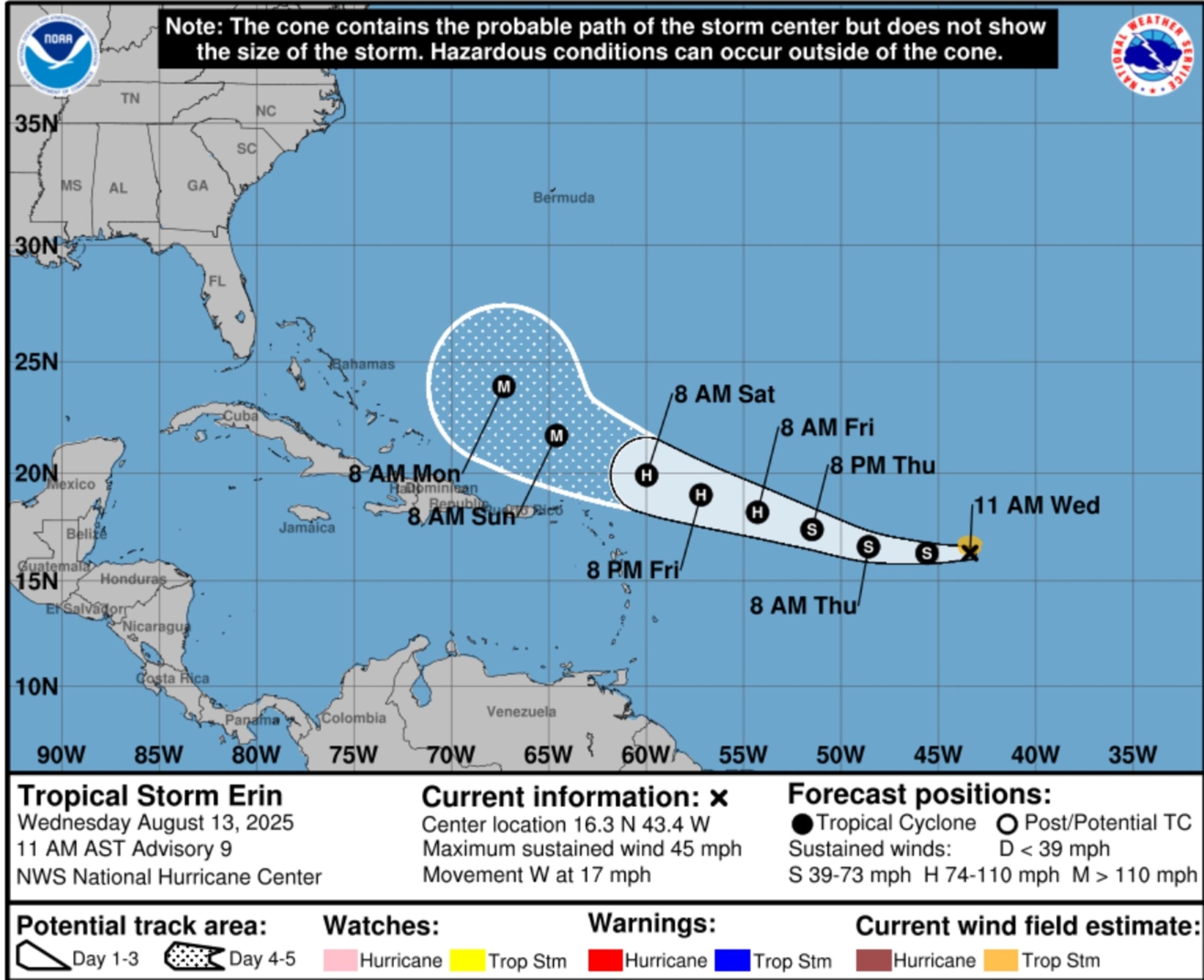
Tropical Storm Erin formed on Monday and continues to march westward across the Atlantic. It is expected to become the Atlantic’s first hurricane of the season later this week, with National Hurricane Center (NHC) meteorologists warning that it could strengthen further into a major hurricane by late this coming weekend.
As of Wednesday afternoon, the storm had maximum sustained wind speeds of 45 miles per hour.
What To Know
Earlier this week, AccuWeather Lead Hurricane Expert Alex DaSilva told Newsweek that the chances of Tropical Storm Erin bringing direct impacts to the U.S. East Coast have increased slightly as its path has shifted more to the south than originally forecast.
“Based on current conditions, forecast atmospheric patterns for the next week, and historical hurricane tracks for this time of year, AccuWeather estimates a 70 percent probability that Erin will not directly impact the U.S. East Coast at this time,” DaSilva said in the email on Wednesday.

National Hurricane Center
On Wednesday, DaSilva told Newsweek that the 30 percent chance of impacts in the U.S. doesn’t mean Erin will make landfall on the East Coast. Rather, the storm will draw near enough to the U.S. to bring rain and wind impacts onshore.
Even if it doesn’t unleash rain and wind on the U.S., Erin will bring dangerous impacts to East Coast beaches by causing big waves and rip currents.
“Families heading to Atlantic beaches this weekend and next week for a late-summer vacation need to be careful,” DaSilva said in the AccuWeather email. “Rip currents can be deadly. More than 50 people have lost their lives to rip currents and rough surf at beaches across the country so far this year.”
The NHC also expressed uncertainty about Erin’s U.S. impacts in its most recent key message about the storm on Wednesday morning.
“Erin could move close enough to the northern Leeward Islands, the Virgin Islands, and Puerto Rico over the weekend to produce some impacts on those islands,” a key message for the storm said.
“However, the magnitude of those impacts is still not known, and interests there should continue to monitor the progress of this storm. There is even greater uncertainty in what impacts might occur in portions of the Greater Antilles, the Bahamas, the east coast of the United States, and Bermuda next week.”
What People Are Saying
Meteorologist Max Velocity in a post on X on Wednesday: “NORTHERN TURN now highlighted in the latest advisory cone for Tropical Storm Erin, however US impacts are still not completely ruled out.”
The National Hurricane Center, in a public advisory about Tropical Storm Erin: “Swells generated by Erin will begin affecting portions of the northern Leeward Islands, the Virgin Islands and Puerto Rico by this weekend. These swells are likely to cause life-threatening surf and rip current conditions. Please consult products from your local weather forecast office.”
What Happens Next
Meteorologists will continue monitoring the storm closely as it progresses. Regardless of landfall, people in hurricane-prone areas are urged to prepare for such a storm now, before the peak of hurricane season hits in September.